New Zealand again, this time it's the bottom bit
Morning all.
Right, where were we? Northland blah blah blah, smelly middle bit yadda yadda yadda, took a ferry and we're here in the South Island.
We landed at Picton and promptly left. Heading west to the National Parks we found ourselves in Blenheim, which is south, and considered the possibility of investing in a compass. In the absence of a compass we decided to follow the road signs and wouldn't you know it, a couple of days later we were paddling around the Abel Tasman National Park.
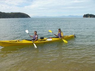
We had a guide for the first day, then a day on our own, and finally a day tramping up to our pick up point (Marahau to Anchorage to Onetahuti to Totaranui for those that have been). Now with all those days we're gonna need some nights to fill the gaps, which luckily or unluckily, depending on your personal comfort requirements, means a spot of camping. Our first night was spent here...

That's Anchorage. Blue skies, calm seas. Nice. We don't like to talk about the second night - let's just say it rained, hard, and puddles should be OUTSIDE the tent.
So anyway, we paddled about, saw some seals...

met lots of hungry sandflies and had a great time. Even so, it was great to come home to Vinnie (remember, he's our van) and a nice cuppa with Tim Tams.
Now, in case your wondering, Tim Tams are kinda like the Penguins we get in England, only according to most Aussies we met in Fernie it's possible to use them like a straw and suck up your drink through the soft bit in the middle. This, I discovered over a packet of minty ones, and believe me I researched this thoroughly, is utter rubbish. What actually happens is they melt into a chocolately biscuit goo, which generally ends up in the cup, and while this is in no means a bad thing, I still feel cheated.
Right, sorry, kinda got distracted there for a minute. Time to head for the West Coast.
Set sail for Westport via the Buller Gorge, and then up to Karamea which is pretty much the end of the road. It rained again. This became something of a feature of the South Island, and not just on the west coast as they'd have you believe - the Southern Alps are supposed to shield the east from the worst of the weather. Lies I tell you; We had the most impressive two days of rain in Dunedin which caused huge amounts of flooding and general chaos. Getting ahead of myself a bit, let's have a look at what's to see around the Karamea area. Well there's walks like this (Oparara Arch)...
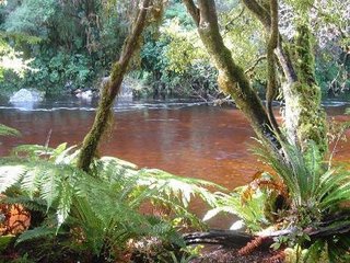
To places like this (Moria Gate)...

Time to head for the Glaciers now. Drove down the west coast past Punakaikai, which is known for it's Pancake Rocks. Lots of Shags in New Zealand, these are Spotted Shags (without their breeding plummage - post-shag Shags I suppose you could say)...

Clearly Kiwis like their pancakes in the American style. I was expecting more of the rolled English style with lemon and sugar which would have been far more impressive. OK, time for the glaciers. Firstly the Franz Josef....

and then the Fox...

First impressions were how dirty they are, not like the sparkly white ones we see while skiing, but as this is the only place in the world where glaciers reach down to the rain forest then I guess we should cut them a little slack. As you get closer to the bottom of them, although still a surprising distance away, there are various fences telling you not to go any closer due to "extreme dangers". Seems that the dangers increase if your credit card isn't shown at the guides hut on the way in, so we ducked under a couple to get a better look...

A couple of facts about about the glaciers: Firstly, they're remarkably spritely and travel three times as fast as those in Europe (which would explain my blurry photos) due to the huge amounts of moisture blown in from the Tasman Sea, and secondly, they've been advancing for the past 20 years....not sure how that fits in with the whole global warming theory, but if somebody wants to explain feel free.
OK, enough with the glaciers. Can't afford to hang around there's lots more to see. Another picture...

Right. Looks like Jen's been adding pictures. It's a walk to somewhere - probably a waterfall, they usually are. Let's just admire the view. And while we're taking a little rest, how about a sunset, they do right good ones here...

That's over Lake Wanaka. We turned up on Easter weekend just in time to see the Warbirds Over Wanaka airshow. Lots of old and new planes flying around. You're supposed to pay lots of money to stand in a field and watch them - we're too tight for that so we paid nothing and parked in the field next door. And of course Easter means...

BEER!!!!!!!! Well no, but we were passing and it would've been rude not to have popped in. The picture doesn't actually do justice to the true size of the samples on offer. Those are three of the TINIEST beer glasses you will ever see. But as I was driving I didn't complain too loudly. Anyway, the true meaning of Easter...
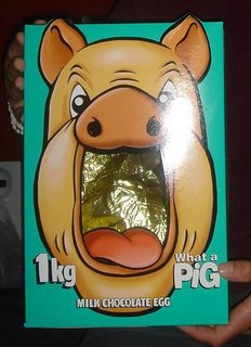
CHOCOLATE!!!!!!!! LOOK AT THE SIZE OF IT!!!! One kilo of chocolate, and as it was hanging around a rather warm van for a couple of days before being eaten, we had to use spoons :-)
Between Wanaka and Queenstown is Arrowtown which we were told (I think by Sam) had a nice golf course. It had been a while since we played so we gave it a go...
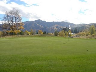
Nice views and a good climb up to the elevated 9th tee. We'll not mention the scores, unfortunately with our lack of talent it's very much the taking part and not the winning. Next stop was Queenstown, which I'm sure some of you know is the extreme sports capital of New Zealand, if not the world. This basically means that you can spend lots and lots of money doing all sorts of daft stuff. At various times of the year they have heli-skiing, heli-biking, jet-boating, bungy jumping, bungy swinging, heli-bungy (I think. If not, why not), jet-swinging (I might be making these up but I don't think so), canyoning, white water rafting and all sorts of other stuff mainly involving big rubber bands, helicopters and jets. Unfortunately nobody could offer heli-jet-bungy-biking so we saved our money and bought cut-price easter eggs instead. We did walk up to the top of the gondola...

for the view of Queenstown and Lake Wakatipu, and then walk down again. Got to justify those easter eggs somehow.
Hi, sorry, got to interrupt you there Col. It seems you were about to move on without so much as a mention of any mushrooms whatsoever. Thank God I'm here. It's been a great month for mushrooms. In particular the hike up to the Gondola was fantastic - imagine walking through Willy Wonkas candy land - now replace the candy with mushrooms... you still with me? great isn't it. mushrooms of all shapes and sizes absolutely littered about all over the place. And as a special treat I have collated a few of my favourite 'shroom pics

The more observant of you will notice that one pic was taken at the golf course. While I'm here I might as well continue....
Moving on from Queenstown we followed one of those Brown signs to the Cliffden limestone Caves, expecting a jolly jaunt with a few well placed stalactites. We hadn't really anticipated a sign next to a hole in the ground, but seeing as a couple of wee children had just completed it alive we got our torches out and crawled in. Now we're not daft, we've been proper caving before, and Col might have mentioned it rains a bit in the South Island; So i don't know why half an hour into the crawling and squeezing I'm surprised to see our way blocked by caves filled with water. It's at this point we recall something else about the kids - they were wet. Anyway, it turns out that I really can reach that extra foot hold and put all my body weight onto just a couple of fingers...

Thanks Jen. Now where were we. Well let's just go to the south coast. It's windy down there. How windy you ask? Well, this was a calm day...
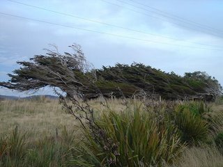
Nuff said. We stayed around Invercargill for a couple of days - it was, as promised, again by Sam, a bit of a dump. But the Bluff Oyster Festival was on so we went along. Lots of Oyster related activity - oyster opening competitions (technically called "shucking"), oyster eating competitions (technically called "gross"), various foods involving oysters. Not being particular fans of oysters we went for the deep fried versions, basically to hide the fact that they were indeed oysters. Not sure who's idea it was to go really....still, it passed the time. We considered going over to Stewart Island, but as we'd have to leave Vinnie somewhere, and the ferry was quite expensive for a day trip, we just took a photo instead and went to the museum.

The main reason to go to the museum was to see Tuatara. They're related to dinosaurs apparently. Meet Henry, according to the blurb he's probably the oldest, biggest and meanest of them all - 100 odd years old, a foot and a half long and very very mean.

However, they don't do much. Imagine that the picture above is a real time video. If you want, imagine it's a time lapse video of a year in the life of a damn Tuatara. Either way, they're pretty damn lazy. Time to leave Invercargill I think. As we'd been to the top of the North Island, it only seemed right to go to the bottom of the South Island. Not much there, just a sign. And wind of course...

They call this area The Catlins - lots of waterfalls and walks and unpaved roads and stuff. Like this waterfall at Purakaunui...

What they also had was penguins. Yellow-eyed penguins in fact which are quite rare, but after sitting in a hide for a bit they eventually came waddling up the beach to nest in the bushes just below us. No doubt Jen will add something more when she reads this, but for now I'll just leave you with the photo. You'll have to excuse the quality - the camera hasn't got much of a zoom so I had to use the binoculars as well....

From this point on it rained. Then it rained some more. And then it rained again. It was quite impressive just how much rain there was and it meant we spent a lot of time sitting around reading (in Dunedin that is, it's just round the corner from the south coast). Except for when we went to the albatross centre and I spent far too long standing in torrential rain trying to spot the damn things. If we weren't so tight we would have paid for the guided tour of the colony, but where's the fun in that.
After two days the rain stopped and we headed back over to Milford Sound - we'd almost gone after leaving Queenstown, but having aborted the drive cos we were likely to run out of diesel and then found out the Underwater Observatory was closed due to too much freshwater (I'll explain in a bit) we'd decided to leave it for a few days. Let's just look at a few piccies...


Pretty good. It's what you'd call a fiord, being a glacier carved valley that's flooded with water. Those steep sided walls are similar below the water. So it's deep but surprisingly calm because of the narrow entrance. As for the observatory, I'll try to explain. It seems that due to the very heavy rainfall in the region and the narrow and shallow entrance to the sound, there is a permanent layer of freshwater on top of the sea water; And because of all the surrounding vegetation there is a very high tannin concentration in the freshwater, which means it's dark in colour. The dark freshwater filters out UV light so that a deep sea environment is duplicated at surprisingly shallow depths - due mainly to the lack of algae I think. Anyway, they've built this underwater observatory - as Jen puts it, it's like a big goldfish bowl with people in it (they've got a website, have a look for yourself)...

Just a couple more photos...

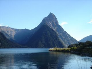
That one was Mitre Peak. Almost forgot the Keas - they are mountain parrots and hang around a car park on the way to the Milford Sound. Playful and inquisitive apparently, which means they'll peck your toes and pull bits off your car...

It's Jen again now... Luckily the Keas left Vinnie alone. He's been through it a bit lately, we've driven him on the beach, and for about 8000km so far, thats a long way by anyone's standards. We almost drove him up the steepest hill in the world, but chickened out after watching a car completely fail to get more than half way and have to back down again, head hung in shame. We did make him drive towards the tallest mountain in New Zealand - Mount Cook - here it is

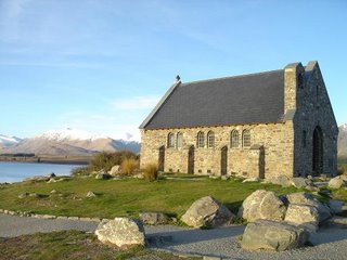
And then he took us to what seemed like the worlds smallest cutest church - the Church of the Good Shephard.
Are you all getting a bit sick of listening to what a great time we're having; how we spent thursday afternoon lounging in the natural hot spring in Hamner...while you were, what were you doing again? :-) OK OK, enough for now.
We're going to leave the South Island now and pop back on the InterIsland Ferry to the North Island again. Got a few glow worms to visit in Waitomo and do some tramping along rather pretty moutains then it's time to leave. Roll end credits....
Don't know where we're going, have no way of knowing
Driving on the road to nowhere
Shirking for a living, meeting men and women
Riding on the road to nowhere
And we don't take shit from anyone
the only thing we're gonna do is have some fun
We're Jen and Colin
(Colin and Jen)
And we like to have a cuppa now and then.
p.s. that will mean a whole lot more to those who recognise the theme tune to british sit com max n paddy
p.p.s. See you in Australia.
Right, where were we? Northland blah blah blah, smelly middle bit yadda yadda yadda, took a ferry and we're here in the South Island.
We landed at Picton and promptly left. Heading west to the National Parks we found ourselves in Blenheim, which is south, and considered the possibility of investing in a compass. In the absence of a compass we decided to follow the road signs and wouldn't you know it, a couple of days later we were paddling around the Abel Tasman National Park.

We had a guide for the first day, then a day on our own, and finally a day tramping up to our pick up point (Marahau to Anchorage to Onetahuti to Totaranui for those that have been). Now with all those days we're gonna need some nights to fill the gaps, which luckily or unluckily, depending on your personal comfort requirements, means a spot of camping. Our first night was spent here...

That's Anchorage. Blue skies, calm seas. Nice. We don't like to talk about the second night - let's just say it rained, hard, and puddles should be OUTSIDE the tent.
So anyway, we paddled about, saw some seals...

met lots of hungry sandflies and had a great time. Even so, it was great to come home to Vinnie (remember, he's our van) and a nice cuppa with Tim Tams.
Now, in case your wondering, Tim Tams are kinda like the Penguins we get in England, only according to most Aussies we met in Fernie it's possible to use them like a straw and suck up your drink through the soft bit in the middle. This, I discovered over a packet of minty ones, and believe me I researched this thoroughly, is utter rubbish. What actually happens is they melt into a chocolately biscuit goo, which generally ends up in the cup, and while this is in no means a bad thing, I still feel cheated.
Right, sorry, kinda got distracted there for a minute. Time to head for the West Coast.
Set sail for Westport via the Buller Gorge, and then up to Karamea which is pretty much the end of the road. It rained again. This became something of a feature of the South Island, and not just on the west coast as they'd have you believe - the Southern Alps are supposed to shield the east from the worst of the weather. Lies I tell you; We had the most impressive two days of rain in Dunedin which caused huge amounts of flooding and general chaos. Getting ahead of myself a bit, let's have a look at what's to see around the Karamea area. Well there's walks like this (Oparara Arch)...

To places like this (Moria Gate)...

Time to head for the Glaciers now. Drove down the west coast past Punakaikai, which is known for it's Pancake Rocks. Lots of Shags in New Zealand, these are Spotted Shags (without their breeding plummage - post-shag Shags I suppose you could say)...

Clearly Kiwis like their pancakes in the American style. I was expecting more of the rolled English style with lemon and sugar which would have been far more impressive. OK, time for the glaciers. Firstly the Franz Josef....

and then the Fox...

First impressions were how dirty they are, not like the sparkly white ones we see while skiing, but as this is the only place in the world where glaciers reach down to the rain forest then I guess we should cut them a little slack. As you get closer to the bottom of them, although still a surprising distance away, there are various fences telling you not to go any closer due to "extreme dangers". Seems that the dangers increase if your credit card isn't shown at the guides hut on the way in, so we ducked under a couple to get a better look...

A couple of facts about about the glaciers: Firstly, they're remarkably spritely and travel three times as fast as those in Europe (which would explain my blurry photos) due to the huge amounts of moisture blown in from the Tasman Sea, and secondly, they've been advancing for the past 20 years....not sure how that fits in with the whole global warming theory, but if somebody wants to explain feel free.
OK, enough with the glaciers. Can't afford to hang around there's lots more to see. Another picture...

Right. Looks like Jen's been adding pictures. It's a walk to somewhere - probably a waterfall, they usually are. Let's just admire the view. And while we're taking a little rest, how about a sunset, they do right good ones here...

That's over Lake Wanaka. We turned up on Easter weekend just in time to see the Warbirds Over Wanaka airshow. Lots of old and new planes flying around. You're supposed to pay lots of money to stand in a field and watch them - we're too tight for that so we paid nothing and parked in the field next door. And of course Easter means...

BEER!!!!!!!! Well no, but we were passing and it would've been rude not to have popped in. The picture doesn't actually do justice to the true size of the samples on offer. Those are three of the TINIEST beer glasses you will ever see. But as I was driving I didn't complain too loudly. Anyway, the true meaning of Easter...

CHOCOLATE!!!!!!!! LOOK AT THE SIZE OF IT!!!! One kilo of chocolate, and as it was hanging around a rather warm van for a couple of days before being eaten, we had to use spoons :-)
Between Wanaka and Queenstown is Arrowtown which we were told (I think by Sam) had a nice golf course. It had been a while since we played so we gave it a go...

Nice views and a good climb up to the elevated 9th tee. We'll not mention the scores, unfortunately with our lack of talent it's very much the taking part and not the winning. Next stop was Queenstown, which I'm sure some of you know is the extreme sports capital of New Zealand, if not the world. This basically means that you can spend lots and lots of money doing all sorts of daft stuff. At various times of the year they have heli-skiing, heli-biking, jet-boating, bungy jumping, bungy swinging, heli-bungy (I think. If not, why not), jet-swinging (I might be making these up but I don't think so), canyoning, white water rafting and all sorts of other stuff mainly involving big rubber bands, helicopters and jets. Unfortunately nobody could offer heli-jet-bungy-biking so we saved our money and bought cut-price easter eggs instead. We did walk up to the top of the gondola...

for the view of Queenstown and Lake Wakatipu, and then walk down again. Got to justify those easter eggs somehow.
Hi, sorry, got to interrupt you there Col. It seems you were about to move on without so much as a mention of any mushrooms whatsoever. Thank God I'm here. It's been a great month for mushrooms. In particular the hike up to the Gondola was fantastic - imagine walking through Willy Wonkas candy land - now replace the candy with mushrooms... you still with me? great isn't it. mushrooms of all shapes and sizes absolutely littered about all over the place. And as a special treat I have collated a few of my favourite 'shroom pics

The more observant of you will notice that one pic was taken at the golf course. While I'm here I might as well continue....
Moving on from Queenstown we followed one of those Brown signs to the Cliffden limestone Caves, expecting a jolly jaunt with a few well placed stalactites. We hadn't really anticipated a sign next to a hole in the ground, but seeing as a couple of wee children had just completed it alive we got our torches out and crawled in. Now we're not daft, we've been proper caving before, and Col might have mentioned it rains a bit in the South Island; So i don't know why half an hour into the crawling and squeezing I'm surprised to see our way blocked by caves filled with water. It's at this point we recall something else about the kids - they were wet. Anyway, it turns out that I really can reach that extra foot hold and put all my body weight onto just a couple of fingers...

Thanks Jen. Now where were we. Well let's just go to the south coast. It's windy down there. How windy you ask? Well, this was a calm day...

Nuff said. We stayed around Invercargill for a couple of days - it was, as promised, again by Sam, a bit of a dump. But the Bluff Oyster Festival was on so we went along. Lots of Oyster related activity - oyster opening competitions (technically called "shucking"), oyster eating competitions (technically called "gross"), various foods involving oysters. Not being particular fans of oysters we went for the deep fried versions, basically to hide the fact that they were indeed oysters. Not sure who's idea it was to go really....still, it passed the time. We considered going over to Stewart Island, but as we'd have to leave Vinnie somewhere, and the ferry was quite expensive for a day trip, we just took a photo instead and went to the museum.

The main reason to go to the museum was to see Tuatara. They're related to dinosaurs apparently. Meet Henry, according to the blurb he's probably the oldest, biggest and meanest of them all - 100 odd years old, a foot and a half long and very very mean.

However, they don't do much. Imagine that the picture above is a real time video. If you want, imagine it's a time lapse video of a year in the life of a damn Tuatara. Either way, they're pretty damn lazy. Time to leave Invercargill I think. As we'd been to the top of the North Island, it only seemed right to go to the bottom of the South Island. Not much there, just a sign. And wind of course...

They call this area The Catlins - lots of waterfalls and walks and unpaved roads and stuff. Like this waterfall at Purakaunui...

What they also had was penguins. Yellow-eyed penguins in fact which are quite rare, but after sitting in a hide for a bit they eventually came waddling up the beach to nest in the bushes just below us. No doubt Jen will add something more when she reads this, but for now I'll just leave you with the photo. You'll have to excuse the quality - the camera hasn't got much of a zoom so I had to use the binoculars as well....

From this point on it rained. Then it rained some more. And then it rained again. It was quite impressive just how much rain there was and it meant we spent a lot of time sitting around reading (in Dunedin that is, it's just round the corner from the south coast). Except for when we went to the albatross centre and I spent far too long standing in torrential rain trying to spot the damn things. If we weren't so tight we would have paid for the guided tour of the colony, but where's the fun in that.
After two days the rain stopped and we headed back over to Milford Sound - we'd almost gone after leaving Queenstown, but having aborted the drive cos we were likely to run out of diesel and then found out the Underwater Observatory was closed due to too much freshwater (I'll explain in a bit) we'd decided to leave it for a few days. Let's just look at a few piccies...


Pretty good. It's what you'd call a fiord, being a glacier carved valley that's flooded with water. Those steep sided walls are similar below the water. So it's deep but surprisingly calm because of the narrow entrance. As for the observatory, I'll try to explain. It seems that due to the very heavy rainfall in the region and the narrow and shallow entrance to the sound, there is a permanent layer of freshwater on top of the sea water; And because of all the surrounding vegetation there is a very high tannin concentration in the freshwater, which means it's dark in colour. The dark freshwater filters out UV light so that a deep sea environment is duplicated at surprisingly shallow depths - due mainly to the lack of algae I think. Anyway, they've built this underwater observatory - as Jen puts it, it's like a big goldfish bowl with people in it (they've got a website, have a look for yourself)...

Just a couple more photos...


That one was Mitre Peak. Almost forgot the Keas - they are mountain parrots and hang around a car park on the way to the Milford Sound. Playful and inquisitive apparently, which means they'll peck your toes and pull bits off your car...

It's Jen again now... Luckily the Keas left Vinnie alone. He's been through it a bit lately, we've driven him on the beach, and for about 8000km so far, thats a long way by anyone's standards. We almost drove him up the steepest hill in the world, but chickened out after watching a car completely fail to get more than half way and have to back down again, head hung in shame. We did make him drive towards the tallest mountain in New Zealand - Mount Cook - here it is

And then he took us to what seemed like the worlds smallest cutest church - the Church of the Good Shephard.

Are you all getting a bit sick of listening to what a great time we're having; how we spent thursday afternoon lounging in the natural hot spring in Hamner...while you were, what were you doing again? :-) OK OK, enough for now.
We're going to leave the South Island now and pop back on the InterIsland Ferry to the North Island again. Got a few glow worms to visit in Waitomo and do some tramping along rather pretty moutains then it's time to leave. Roll end credits....
Don't know where we're going, have no way of knowing
Driving on the road to nowhere
Shirking for a living, meeting men and women
Riding on the road to nowhere
And we don't take shit from anyone
the only thing we're gonna do is have some fun
We're Jen and Colin
(Colin and Jen)
And we like to have a cuppa now and then.
p.s. that will mean a whole lot more to those who recognise the theme tune to british sit com max n paddy
p.p.s. See you in Australia.

1 Comments:
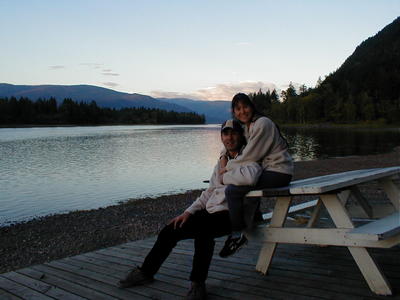
Still no people, then?
And another thing, how do you remember all the names of the places you've visited, especially those with eccentric spellings? Are you keeping a diary or are you making them up as you go along? Well, whatever, the detail is impressive and the pix as good as ever. Enjoy Oz! x
By Tom, at 2:18 am
Post a Comment
<< Home